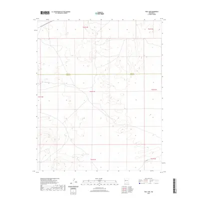
2020 Map of Trail Lake
USGS Topo · Published 2020About this map
Continental Divide National Scenic Trail traverses the high northwestern corner of this territory, marking the watershed boundary in a landscape defined by seasonal catchments and subtle relief. The survey area straddles the high-desert border of Cibola and Catron counties, showing a terrain sparsely marked by human infrastructure outside of the rudimentary Co RD a078. Vital water features like Trail Lake and Canteen Lake appear as key landmarks in this arid environment, likely serving as essential points for local livestock or wildlife management. The absence of established settlements or major highways highlights the remote character of this part of the Southwest, where the Public Land Survey System grid remains the primary organizing feature of the land.
Find a feature on this map
5 named features on this map. Tap any name to fly to it.
Don’t see what you’re looking for? This feature index may not catch every label — zoom into the map to look around manually.
Map Details
Editions of this 2020 Trail Lake Map
This is the sole edition of this map. No revisions or reprints were ever made.
Other maps of this area

1954 · Saint Johns
USGS Topo · 1:250,000

1957 · Saint Johns
USGS Topo · 1:250,000

1958 · Saint Johns
USGS Topo · 1:250,000

1962 · Saint Johns
USGS Topo · 1:250,000
1967 · Tres Lagunas
USGS Topo · 1:24,000
1967 · York Ranch SE
USGS Topo · 1:24,000

1967 · Adams Diggings
USGS Topo · 1:24,000

1967 · Blue Hills
USGS Topo · 1:24,000
1967 · York Ranch
USGS Topo · 1:24,000

1967 · Veteado Mountain
USGS Topo · 1:24,000