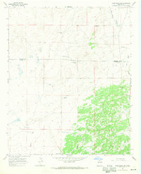
1967 Map of York Ranch SE
USGS Topo · Published 1971About this map
The high desert landscape of Catron Co and Valencia Co centers on a complex network of water infrastructure vital to ranching in the late 1960s. The topography is defined by the broad drainage of Veteado Draw and the rugged contours of Goat Tank Canyon, where elevation changes indicate the transitional terrain between open range and higher ground. This survey reveals a reliance on isolated water sources, documented through numerous family-named or location-specific features such as Clemente Well, Martin Well, and Lowlands Well No 1. Cultural history is noted by the presence of a small Cem and unidentified Ruins in the southeastern quadrant, suggesting earlier habitation in this arid region. The distribution of these wells and tanks like Elsies Tank illustrates the carefully managed land use necessary for livestock in this remote part of New Mexico.
Find a feature on this map
17 named features on this map. Tap any name to fly to it.
Don’t see what you’re looking for? This feature index may not catch every label — zoom into the map to look around manually.
Map Details
Editions of this 1967 York Ranch SE Map
This is the sole edition of this map. No revisions or reprints were ever made.
Other maps of this area

1917 · Broom Mountain
USGS Topo · 1:125,000

1954 · Saint Johns
USGS Topo · 1:250,000

1954 · Socorro
USGS Topo · 1:250,000

1957 · Saint Johns
USGS Topo · 1:250,000

1958 · Socorro
USGS Topo · 1:250,000

1958 · Saint Johns
USGS Topo · 1:250,000

1962 · Socorro
USGS Topo · 1:250,000

1962 · Saint Johns
USGS Topo · 1:250,000
1964 · Sand Canyon
USGS Topo · 1:24,000

1964 · Third Canyon
USGS Topo · 1:24,000