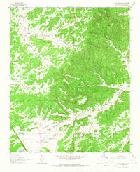
1964 Map of Third Canyon
USGS Topo · Published 1967About this map
McPhaul Ranch sits at the heart of this high-altitude cattle and ranching country within the Cibola National Forest. The landscape is defined by the erosion of the Third Canyon Mesa, where deep drainage systems like Goat Canyon, Harrington Canyon, and Cibola Canyon carve through the terrain toward Alamocita Creek. The infrastructure of the mid-1960s reveals the vital importance of water management in this arid environment, marked by numerous man-made and natural water sources such as Trinchera Lake, Sunflower Lake, and specialized points like Bobcat Well and Freeland Arroyo Tank. A remote Landing Strip near the ranch indicates the necessity of aerial access for these isolated settlements. Geologists and local historians can also identify several Prospect sites, suggesting the mineral exploration that often accompanied ranching in Catron County.
Find a feature on this map
26 named features on this map. Tap any name to fly to it.
Don’t see what you’re looking for? This feature index may not catch every label — zoom into the map to look around manually.
Map Details
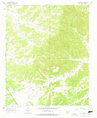
Editions of this 1964 Third Canyon Map
2 editions found
Other maps of this area

1917 · Broom Mountain
USGS Topo · 1:125,000

1954 · Saint Johns
USGS Topo · 1:250,000

1954 · Socorro
USGS Topo · 1:250,000

1957 · Saint Johns
USGS Topo · 1:250,000

1958 · Socorro
USGS Topo · 1:250,000

1958 · Saint Johns
USGS Topo · 1:250,000

1962 · Socorro
USGS Topo · 1:250,000

1962 · Saint Johns
USGS Topo · 1:250,000
1963 · Cal Ship Mesa
USGS Topo · 1:24,000
1964 · Bonine Canyon
USGS Topo · 1:24,000