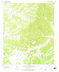
1964 Map of Third Canyon
USGS Topo · Published 1978About this map
McPhaul Ranch sits at the heart of this high-altitude landscape, illustrating the remote ranching operations of central New Mexico in the mid-1960s. The topography is defined by the massive Third Canyon Mesa and a network of drainages including Goat Canyon and Harrington Canyon that feed toward the Rio Salado. The map documents the critical water infrastructure required for survival in this arid environment, marked by numerous isolated features such as Corrals Windmill, Cow Spring, and Bobcat Well.
Find a feature on this map
26 named features on this map. Tap any name to fly to it.
Don’t see what you’re looking for? This feature index may not catch every label — zoom into the map to look around manually.
Map Details
Editions of this 1964 Third Canyon Map
2 editions found
Other maps of this area

1917 · Broom Mountain
USGS Topo · 1:125,000

1954 · Saint Johns
USGS Topo · 1:250,000

1954 · Socorro
USGS Topo · 1:250,000

1957 · Saint Johns
USGS Topo · 1:250,000

1958 · Socorro
USGS Topo · 1:250,000

1958 · Saint Johns
USGS Topo · 1:250,000

1962 · Socorro
USGS Topo · 1:250,000

1962 · Saint Johns
USGS Topo · 1:250,000

1963 · Cal Ship Mesa
USGS Topo · 1:24,000

1964 · Third Canyon
USGS Topo · 1:24,000