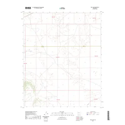
2023 Map of Trail Lake
USGS Topo · Published 2023About this map
Continental Divide National Scenic Trl winds through the northwestern corner of this landscape, marking a significant high-altitude corridor within the Cibola Co Catron Co border region. The area is characterized by isolated water features such as Canteen Lake and the eponymous Trail Lake, which serve as critical landmarks in an otherwise sparse high-desert terrain. Much of the land is organized under the Public Land Survey System, with township boundaries for t4n r13w and t5n r13w defining the administrative layout. Access to this remote portion of New Mexico is limited to unimproved routes and the presence of Co RD a078 in the southeast, reflecting a region primarily dedicated to wilderness preservation and traditional rangeland use during the early twenty-first century.
Find a feature on this map
12 named features on this map. Tap any name to fly to it.
Don’t see what you’re looking for? This feature index may not catch every label — zoom into the map to look around manually.
Map Details
Editions of this 2023 Trail Lake Map
This is the sole edition of this map. No revisions or reprints were ever made.
Other maps of this area

1954 · Saint Johns
USGS Topo · 1:250,000

1957 · Saint Johns
USGS Topo · 1:250,000

1958 · Saint Johns
USGS Topo · 1:250,000

1962 · Saint Johns
USGS Topo · 1:250,000
1967 · Tres Lagunas
USGS Topo · 1:24,000
1967 · York Ranch SE
USGS Topo · 1:24,000

1967 · Adams Diggings
USGS Topo · 1:24,000

1967 · Blue Hills
USGS Topo · 1:24,000
1967 · York Ranch
USGS Topo · 1:24,000

1967 · Veteado Mountain
USGS Topo · 1:24,000