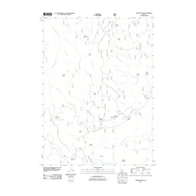
2011 Map of Trapper Peak
USGS Topo · Published 2011About this map
Trapper Peak and its surrounding high-elevation landscape define this portion of Cassia County, where the hydrology is dominated by the complex drainage of Third Fork Rock Creek, First Fork Rock Creek, and Second Fork Rock Creek. This 2011 survey illustrates a region largely dedicated to recreation and grazing, featuring landmarks like Father and Sons Campground and Bostetter Campground alongside the historic livestock infrastructure of Fuller Pasture and Bostetter Pasture. The map's labeling reveals a legacy of spring-based water management, including Cabin Spring Number Two and Bear Gulch Spring. High points such as Flatiron Mountain, Harrington Peak, and Monument Peak provide topographic orientation, while the remote Oakley-Rogerson Rd serves as a primary transit corridor through the jagged valleys and gulches that characterize this Idaho backcountry.
Find a feature on this map
75 named features on this map. Tap any name to fly to it.
Don’t see what you’re looking for? This feature index may not catch every label — zoom into the map to look around manually.
Map Details
Editions of this 2011 Trapper Peak Map
This is the sole edition of this map. No revisions or reprints were ever made.
Other maps of this area

1955 · Twin Falls
USGS Topo · 1:250,000

1958 · Twin Falls
USGS Topo · 1:250,000

1965 · Rams Horn Ridge
USGS Topo · 1:24,000

1965 · Grand View Peak
USGS Topo · 1:24,000

1965 · Buckhorn Canyon
USGS Topo · 1:24,000

1977 · Timber Butte
USGS Topo · 1:24,000

1977 · Mahogany Butte
USGS Topo · 1:24,000
1977 · Ibex Peak
USGS Topo · 1:24,000
1978 · Pike Mountain
USGS Topo · 1:24,000
1978 · Severe Spring
USGS Topo · 1:24,000