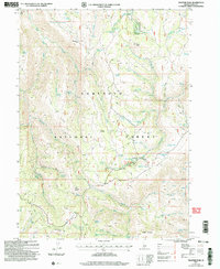
2001 Map of Trapper Peak
USGS Topo · Published 2006About this map
Sawtooth National Forest dominates this landscape, covering a high-elevation backcountry defined by prominent summits and specialized grazing infrastructure. Central to the sheet, Trapper Peak and Flatiron Mountain rise above a network of canyons where water sources were critical for the livestock economy. The presence of numerous named springs, such as Worm Corral Spring and Coal Pit Spring, alongside various corral sites and the White Stump landmark, highlights the area's historical use for range management.
Find a feature on this map
70 named features on this map. Tap any name to fly to it.
Don’t see what you’re looking for? This feature index may not catch every label — zoom into the map to look around manually.
Map Details
Editions of this 2001 Trapper Peak Map
This is the sole edition of this map. No revisions or reprints were ever made.
Other maps of this area

1955 · Twin Falls
USGS Topo · 1:250,000

1958 · Twin Falls
USGS Topo · 1:250,000

1965 · Rams Horn Ridge
USGS Topo · 1:24,000

1965 · Grand View Peak
USGS Topo · 1:24,000

1965 · Buckhorn Canyon
USGS Topo · 1:24,000

1977 · Timber Butte
USGS Topo · 1:24,000

1977 · Mahogany Butte
USGS Topo · 1:24,000
1977 · Ibex Peak
USGS Topo · 1:24,000
1978 · Pike Mountain
USGS Topo · 1:24,000
1978 · Severe Spring
USGS Topo · 1:24,000