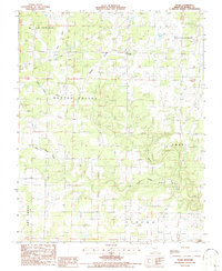
1986 Map of Trask
USGS Topo · Published 1986About this map
Hutton Valley and Goldsberry anchor this mid-1980s Missouri landscape, where the Ozark terrain is defined by its deep hollows and winding creek beds. The map illustrates a rural settlement pattern centered on crossroads like Trask and Sisson, with family and community history etched into the land at locations like Chapel and various unmarked Cem sites. The drainage of Eleven Point River and the meandering path of Lost Camp Creek dominate the topography, revealing how the water network dictated the placement of roads and homesteads. High points are utilized for essential infrastructure, notably the Lookout Tower (Radio Tower) near the northern boundary. The contrast between the broad Sims Valley and the narrow Robbins Hollow highlights the varied relief that characterizes this portion of Howell County.
Find a feature on this map
18 named features on this map. Tap any name to fly to it.
Don’t see what you’re looking for? This feature index may not catch every label — zoom into the map to look around manually.
Map Details
Editions of this 1986 Trask Map
This is the sole edition of this map. No revisions or reprints were ever made.
Other maps of this area

1945 · Willow Springs
USGS Topo · 1:62,500

1945 · Montier
USGS Topo · 1:62,500

1945 · Clear Springs
USGS Topo · 1:62,500

1946 · Summersville
USGS Topo · 1:62,500

1948 · Clear Springs
USGS Topo · 1:62,500

1948 · Montier
USGS Topo · 1:62,500

1948 · Willow Springs
USGS Topo · 1:62,500

1948 · Summersville
USGS Topo · 1:62,500

1949 · Rolla
USGS Topo · 1:250,000

1953 · Rolla
USGS Topo · 1:250,000