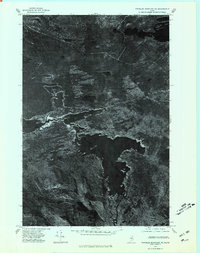
1975 Map of Traveler Mountain NE
USGS Topo · Published 1981About this map
Grand Lake Matagamon dominates this 1975 orthophotograph, its dark waters contrasting against the wooded terrain of north-central Maine. The map provides a unique visual record of the landscape just before the 1980s, documenting the spatial relationship between the sprawling lake and the elevated peaks of Trout Brook Mountain and Billfish Mountain. A small pocket of human activity is visible at Trout Brook Farm, situated near the confluence of Trout Brook and the lake. Further north, the isolated Scraggly Lake sits tucked away in the forest. Unlike traditional topographic maps, this orthophotoquad uses rectified aerial imagery to show the actual density of timber and the precise contours of the shoreline and marshy inlets, offering a literal view of the Penobscot wilderness during the mid-seventies.
Find a feature on this map
6 named features on this map. Tap any name to fly to it.
Don’t see what you’re looking for? This feature index may not catch every label — zoom into the map to look around manually.
Map Details
Editions of this 1975 Traveler Mountain NE Map
This is the sole edition of this map. No revisions or reprints were ever made.
Other maps of this area

1954 · Shin Pond
USGS Topo · 1:62,500

1954 · Millinocket Lake
USGS Topo · 1:62,500

1954 · Grand Lake Seboeis
USGS Topo · 1:62,500

1954 · Presque Isle
USGS Topo · 1:250,000

1955 · Traveler Mountain
USGS Topo · 1:62,500

1958 · Presque Isle
USGS Topo · 1:250,000

1960 · Presque Isle
USGS Topo · 1:250,000
1975 · The Traveler
USGS Topo · 1:24,000
1975 · Shin Pond SW
USGS Topo · 1:24,000
1975 · Shin Pond NW
USGS Topo · 1:24,000