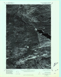
1975 Map of Traveler Mountain NW
USGS Topo · Published 1981About this map
Grand Lake Matagamon dominates the eastern edge of this 1975 orthophotoquad, which uses aerial photography to document the North Woods landscape of Maine. This specific format replaces traditional topographic lines with a high-contrast overhead image, revealing the raw texture of the timberlands and the intricate drainage patterns of the region. The map shows the winding course of Webster Brook as it flows toward the lake, alongside the path of Trout Brook. For researchers of the Maine wilderness, these images provide a clear record of forest cover and shoreline conditions at the mid-1970s, before modern shifts in land management and logging infrastructure changed the character of the backcountry.
Find a feature on this map
3 named features on this map. Tap any name to fly to it.
Don’t see what you’re looking for? This feature index may not catch every label — zoom into the map to look around manually.
Map Details
Editions of this 1975 Traveler Mountain NW Map
This is the sole edition of this map. No revisions or reprints were ever made.
Other maps of this area

1953 · Telos Lake
USGS Topo · 1:62,500

1954 · Spider Lake
USGS Topo · 1:62,500

1954 · Millinocket Lake
USGS Topo · 1:62,500

1954 · Presque Isle
USGS Topo · 1:250,000

1955 · Traveler Mountain
USGS Topo · 1:62,500

1957 · Telos Lake
USGS Topo · 1:62,500

1958 · Presque Isle
USGS Topo · 1:250,000

1960 · Presque Isle
USGS Topo · 1:250,000

1961 · Spider Lake
USGS Topo · 1:62,500
1975 · The Traveler
USGS Topo · 1:24,000