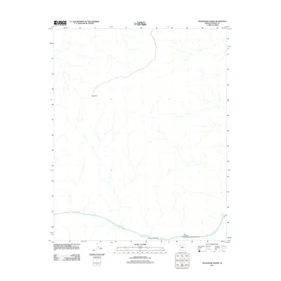
2011 Map of Travertine Rapids
USGS Topo · Published 2011About this map
The Colorado River carves through the lower reaches of this Mohave County landscape, marked by a series of treacherous river features including Two Hundred and Thirtytwo Mile Rapids and the notably named Travertine Rapids. The map illustrates a stark, hydrography-focused terrain where water and geology are the primary actors. Notable landforms such as Kelly Point overlook the deep drainage systems of Two Hundred and Twentyeightmile Canyon and Travertine Canyon. This 2011 survey records the river's path through the canyon floor, capturing the specific locations of landmarks like Travertine Falls and Diamond Creek Rapids. The absence of developed roads or settlements highlights the isolation of this river corridor, making it a vital reference for those studying the river's navigational hazards and the geological structures of the Arizona canyonlands.
Find a feature on this map
9 named features on this map. Tap any name to fly to it.
Don’t see what you’re looking for? This feature index may not catch every label — zoom into the map to look around manually.
Map Details
Editions of this 2011 Travertine Rapids Map
This is the sole edition of this map. No revisions or reprints were ever made.
Other maps of this area

1886 · Diamond Creek
USGS Topo · 1:250,000

1892 · Diamond Creek
USGS Topo · 1:250,000

1948 · Williams
USGS Topo · 1:250,000

1954 · Williams
USGS Topo · 1:250,000

1956 · Williams
USGS Topo · 1:250,000

1960 · Williams
USGS Topo · 1:250,000

1961 · Williams
USGS Topo · 1:250,000
1967 · Granite Park
USGS Topo · 1:24,000
1967 · Travertine Rapids
USGS Topo · 1:24,000
1967 · Peach Springs Canyon
USGS Topo · 1:24,000