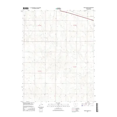
2015 Map of Trego Center NE
USGS Topo · Published 2015About this map
Big Cr meanders across this rural section of Trego County, defining the drainage patterns of a landscape marked by a disciplined grid of agricultural roads. This 2015 survey illustrates the modern layout of the High Plains, where the land is divided into systematic townships such as t12s r23w and t12s r22w. The northern edge of the map is dominated by the primary transportation corridor of Interstate 70, which runs parallel to the historic path of Old Hwy 40. The secondary road network is identified by a sequential alphanumeric system, including K Rd and L Rd crossing north-south avenues like 290 Ave. This structure reflects a century of land management and provides a clear record of property boundaries and local infrastructure in this Kansas wheat-growing region.
Find a feature on this map
22 named features on this map. Tap any name to fly to it.
Don’t see what you’re looking for? This feature index may not catch every label — zoom into the map to look around manually.
Map Details
Editions of this 2015 Trego Center NE Map
This is the sole edition of this map. No revisions or reprints were ever made.
Other maps of this area

1893 · Ellis
USGS Topo · 1:125,000

1893 · Hill
USGS Topo · 1:125,000

1955 · Great Bend
USGS Topo · 1:250,000

1955 · Beloit
USGS Topo · 1:250,000

1957 · Great Bend
USGS Topo · 1:250,000

1958 · Great Bend
USGS Topo · 1:250,000

1959 · Beloit
USGS Topo · 1:250,000
1960 · Trego Center
USGS Topo · 1:24,000
1960 · Trego Center NE
USGS Topo · 1:24,000
1961 · Ogallah
USGS Topo · 1:24,000