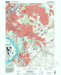
1995 Map of Trenton East
USGS Topo · Published 2000About this map
The Delaware River serves as the focal point for this mid-1990s landscape, marking the historic boundary between New Jersey and Pennsylvania. On the eastern banks, the dense residential and industrial sprawl of Trenton gives way to suburban developments such as Hamilton Square and Mercerville. Along the southern reach, Bordentown sits near the confluence of Crosswicks Creek, where the Delaware and Raritan Canal State Park offers a preserved corridor of transport history. The map captures a high degree of institutional development, featuring the State Youth Correctional Facility and the State Industrial School. Recreational and religious sites are scattered throughout, from the Roebling Memorial County Park to St Anthonys Convent, illustrating the complex social fabric of Mercer County during this era of continued regional expansion.
Find a feature on this map
93 named features on this map. Tap any name to fly to it.
Don’t see what you’re looking for? This feature index may not catch every label — zoom into the map to look around manually.
Map Details
Editions of this 1995 Trenton East Map
This is the sole edition of this map. No revisions or reprints were ever made.
Other maps of this area

1888 · Bordentown
USGS Topo · 1:62,500

1888 · Princeton
USGS Topo · 1:62,500

1890 · Lambertville
USGS Topo · 1:62,500

1890 · Burlington
USGS Topo · 1:62,500

1891 · Lambertville
USGS Topo · 1:62,500

1893 · Bordentown
USGS Topo · 1:62,500

1893 · Burlington
USGS Topo · 1:62,500

1894 · Princeton
USGS Topo · 1:62,500

1894 · Lambertville
USGS Topo · 1:62,500

1904 · Burlington
USGS Topo · 1:62,500