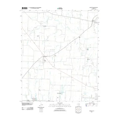
2010 Map of Trenton
USGS Topo · Published 2010About this map
Trenton serves as the central hub of this North Texas landscape, where the intersection of highways and local routes anchors a network of smaller communities including Orangeville, Union Hill, and Delba. The terrain is defined by the headwaters of numerous creeks, most notably Bois d'Arc Creek and its many tributaries like Brushy Creek and Blanton Creek. This 2010 survey highlights a largely agricultural and rural residential character, though the presence of the Red Wing Airport and Casey Field indicates a modern layer of local infrastructure beyond farming.
Find a feature on this map
78 named features on this map. Tap any name to fly to it.
Don’t see what you’re looking for? This feature index may not catch every label — zoom into the map to look around manually.
Map Details
Editions of this 2010 Trenton Map
This is the sole edition of this map. No revisions or reprints were ever made.
Other maps of this area

1954 · Sherman
USGS Topo · 1:250,000

1958 · Bonham
USGS Topo · 1:62,500

1958 · Whitesright
USGS Topo · 1:62,500

1958 · Sherman
USGS Topo · 1:250,000

1960 · Blue Ridge
USGS Topo · 1:24,000

1960 · Pike
USGS Topo · 1:24,000

1964 · Trenton
USGS Topo · 1:24,000
1964 · Pilot Grove
USGS Topo · 1:24,000

1964 · Celeste
USGS Topo · 1:24,000
1964 · Leonard
USGS Topo · 1:24,000