
1960 Map of Blue Ridge
USGS Topo · Published 1962About this map
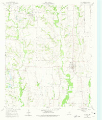
Blue Ridge serves as a primary hub for this rural portion of Collin County, anchored by its proximity to the drainage of Desert Creek and Grove Creek. The landscape is defined by its numerous small settlements and agricultural crossroads, including Westminster, Valdasta, and Verona. Genealogists will find significant value in the detailed placement of local burial sites like Westminster Cem and the Old Grounds Cem, along with the Snow Hill Ch in the southeast. Water management is a visible priority for the North Texas Municipal Water District, evidenced by the presence of Reservoir No 10 and Reservoir No 11 near Chambliss. The northern portion of the map near Westminster shows a concentrated cluster of structures around a central bench mark, indicating the town's role as a local center of commerce and community in the early 1960s.
Find a feature on this map
34 named features on this map. Tap any name to fly to it.
Don’t see what you’re looking for? This feature index may not catch every label — zoom into the map to look around manually.
Map Details
Editions of this 1960 Blue Ridge Map
2 editions found
Other maps of this area

1929 · McKinney
USGS Topo · 1:62,500

1930 · Farmersville
USGS Topo · 1:62,500

1954 · Sherman
USGS Topo · 1:250,000

1958 · Sherman
USGS Topo · 1:250,000

1960 · McKinney East
USGS Topo · 1:24,000

1960 · Pike
USGS Topo · 1:24,000

1960 · Culleoka
USGS Topo · 1:24,000

1961 · Van Alstyne
USGS Topo · 1:24,000
1961 · Anna
USGS Topo · 1:24,000

1962 · Farmersville
USGS Topo · 1:24,000