
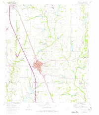
1961 Map of Van Alstyne
USGS Topo · Published 1963About this map
Van Alstyne and Howe anchor this North Texas survey, positioned along the busy corridor of the Southern Pacific railroad. The landscape is defined by the branching tributaries of the Red River and Trinity River basins, including the Hurricane Creek drainage and the prongs of West Prong Whites Creek and West Prong Sister Grove Creek. These waterways dictate the placement of early rural landmarks and industry, such as the numerous Quarries and Gravel Pits that dot the countryside. Near the Grayson and Collin County line, the map reveals a network of country burial grounds including Morris Cem, Cannon Cem, and Baker Cem, alongside local gathering places like Sister Grove Ch. The presence of an Athletic Field and localized sewage disposal facilities reflects the mid-century municipal expansion of these farming communities.
Find a feature on this map
21 named features on this map. Tap any name to fly to it.
Don’t see what you’re looking for? This feature index may not catch every label — zoom into the map to look around manually.
Map Details
Editions of this 1961 Van Alstyne Map
2 editions found
Other maps of this area

1901 · Denison
USGS Topo · 1:125,000

1954 · Sherman
USGS Topo · 1:250,000

1958 · Dorchester
USGS Topo · 1:24,000

1958 · Whitesright
USGS Topo · 1:62,500

1958 · Sherman
USGS Topo · 1:250,000

1958 · Sherman
USGS Topo · 1:62,500

1958 · Howe
USGS Topo · 1:24,000

1960 · Blue Ridge
USGS Topo · 1:24,000

1961 · Gunter
USGS Topo · 1:24,000
1961 · Weston
USGS Topo · 1:24,000