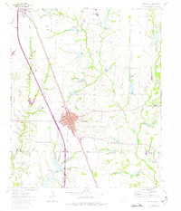
1961 Map of Van Alstyne
USGS Topo · Published 1975About this map
Van Alstyne stands as a primary rail hub in this mid-century survey, centered on the Southern Pacific line. The town's grid expands around Stephens and Jefferson streets, showing the urban footprint as it existed in 1961 with later aerial revisions highlighting its growth. Outside the main settlement, the landscape of the Grayson Co Collin Co border is defined by numerous drainage systems including Hurricane Creek and Sister Grove Creek. Local history is deeply etched into the rural sections through numerous family and community landmarks. Researchers will find several burial grounds such as Morris Cem, Baker Cem, and Cannon Cem, alongside rural institutions like Sister Grove Ch. Industrial activity is evident in the scattered Quarry and Gravel Pits that punctuate the plains, while Old Telephone Road marks an earlier era of transit through the Texas blackland prairie.
Find a feature on this map
27 named features on this map. Tap any name to fly to it.
Don’t see what you’re looking for? This feature index may not catch every label — zoom into the map to look around manually.
Map Details
Editions of this 1961 Van Alstyne Map
2 editions found
Other maps of this area

1901 · Denison
USGS Topo · 1:125,000

1954 · Sherman
USGS Topo · 1:250,000

1958 · Dorchester
USGS Topo · 1:24,000

1958 · Whitesright
USGS Topo · 1:62,500

1958 · Sherman
USGS Topo · 1:250,000

1958 · Sherman
USGS Topo · 1:62,500

1958 · Howe
USGS Topo · 1:24,000

1960 · Blue Ridge
USGS Topo · 1:24,000

1961 · Gunter
USGS Topo · 1:24,000

1961 · Van Alstyne
USGS Topo · 1:24,000