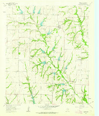
1961 Map of Weston
USGS Topo · Published 1963About this map
Weston and the surrounding blackland prairies of Collin County are captured here just as the post-war era began to reshape north Texas. The landscape is defined by the winding course of Honey Creek, which feeds a network of smaller tributaries like Howell Branch and Long Branch across the central terrain. Small rural communities such as Chambersville, Roland, and Rhea Mills anchor the corners of the sheet, reflecting a period of traditional agrarian settlement patterns. For those researching local family history, the map includes several historic burial grounds, including Corinth Cem, Wilson Cem, and Mugg Cem, along with the Cottage Hill Ch. A notable series of impoundments and spillways along the creeks indicates 1950s-era water management practices, while active Gravel Pits and a Quarry point to the local extractive industries supporting regional growth.
Find a feature on this map
22 named features on this map. Tap any name to fly to it.
Don’t see what you’re looking for? This feature index may not catch every label — zoom into the map to look around manually.
Map Details
Editions of this 1961 Weston Map
2 editions found
Other maps of this area

1929 · Frisco
USGS Topo · 1:62,500

1929 · McKinney
USGS Topo · 1:62,500

1954 · Sherman
USGS Topo · 1:250,000

1958 · Sherman
USGS Topo · 1:250,000

1960 · Frisco
USGS Topo · 1:24,000

1960 · McKinney East
USGS Topo · 1:24,000

1960 · Celina
USGS Topo · 1:24,000
1960 · McKinney West
USGS Topo · 1:24,000

1961 · Gunter
USGS Topo · 1:24,000

1961 · Van Alstyne
USGS Topo · 1:24,000