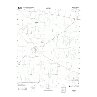
2013 Map of Trenton
USGS Topo · Published 2013About this map
Trenton sits at the heart of this Fannin County landscape, where the intersection of highways and rail lines defines the local geography. The surrounding countryside is characterized by a dense network of small waterways, including Bois d'Arc Cr and Chinquapin Cr, which drain the agricultural land north toward the Red River valley. Small rural centers such as Orangeville, Randolph, and Union Hill are linked by a grid of county roads, reflecting the enduring settlement pattern of North Texas.
Find a feature on this map
113 named features on this map. Tap any name to fly to it.
Don’t see what you’re looking for? This feature index may not catch every label — zoom into the map to look around manually.
Map Details
Editions of this 2013 Trenton Map
This is the sole edition of this map. No revisions or reprints were ever made.
Other maps of this area

1954 · Sherman
USGS Topo · 1:250,000

1958 · Bonham
USGS Topo · 1:62,500

1958 · Whitesright
USGS Topo · 1:62,500

1958 · Sherman
USGS Topo · 1:250,000

1960 · Blue Ridge
USGS Topo · 1:24,000

1960 · Pike
USGS Topo · 1:24,000

1964 · Trenton
USGS Topo · 1:24,000
1964 · Pilot Grove
USGS Topo · 1:24,000

1964 · Celeste
USGS Topo · 1:24,000
1964 · Leonard
USGS Topo · 1:24,000