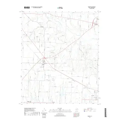
2019 Map of Trenton
USGS Topo · Published 2019About this map
Trenton and Leonard serve as the primary population centers in this southwestern portion of Fannin County, where the Texas landscape is defined by a dense network of creek tributaries. Local drainage is directed through numerous waterways including Bois d'Arc Cr, Cottonwood Cr, and Brushy Cr, which carve through the terrain between established settlements like Orangeville and Randolph. The map reveals a highly developed grid of rural county roads that connect outlying farms and historical sites such as Burns Cem and Bailey Cem. Small-scale aviation is represented by Red Wing Airport near Orangeville and Rockys Place Airport in the south. In the southeastern corner, Thornton Lake provides a rare localized water body amidst the winding paths of Lee Cr and Bear Cr.
Find a feature on this map
120 named features on this map. Tap any name to fly to it.
Don’t see what you’re looking for? This feature index may not catch every label — zoom into the map to look around manually.
Map Details
Editions of this 2019 Trenton Map
This is the sole edition of this map. No revisions or reprints were ever made.
Other maps of this area

1954 · Sherman
USGS Topo · 1:250,000

1958 · Bonham
USGS Topo · 1:62,500

1958 · Whitesright
USGS Topo · 1:62,500

1958 · Sherman
USGS Topo · 1:250,000

1960 · Blue Ridge
USGS Topo · 1:24,000

1960 · Pike
USGS Topo · 1:24,000

1964 · Trenton
USGS Topo · 1:24,000
1964 · Pilot Grove
USGS Topo · 1:24,000

1964 · Celeste
USGS Topo · 1:24,000
1964 · Leonard
USGS Topo · 1:24,000