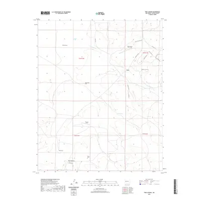
2020 Map of Tres Lagunas
USGS Topo · Published 2020About this map
Tres Lagunas and the small settlement of Lehew anchor this high-altitude landscape in Catron County, where water management is the primary driver of human geography. The terrain is defined by a series of drainage systems including Freeland Arroyo, Newton Draw, and Still Canyon, which feed into numerous livestock watering points such as Hubbell Tank, Dike Tank, and Mud Tank. For family historians, the Tres Lagunas Cem serves as a critical local landmark. The presence of both the Dream Catcher Ranch Airport and the Poco Loco Airport indicates a reliance on private aviation for connectivity in this part of New Mexico. Modern subdivision patterns are visible in the eastern portion of the map, where residential roads like Ponderosa View Lp and Allegres Cir show recent attempts to establish ranch-style housing developments among the ancient draws and arroyos.
Find a feature on this map
30 named features on this map. Tap any name to fly to it.
Don’t see what you’re looking for? This feature index may not catch every label — zoom into the map to look around manually.
Map Details
Editions of this 2020 Tres Lagunas Map
This is the sole edition of this map. No revisions or reprints were ever made.
Other maps of this area

1917 · Broom Mountain
USGS Topo · 1:125,000

1954 · Saint Johns
USGS Topo · 1:250,000

1954 · Socorro
USGS Topo · 1:250,000

1957 · Saint Johns
USGS Topo · 1:250,000

1958 · Socorro
USGS Topo · 1:250,000

1958 · Saint Johns
USGS Topo · 1:250,000

1962 · Socorro
USGS Topo · 1:250,000

1962 · Saint Johns
USGS Topo · 1:250,000

1964 · Third Canyon
USGS Topo · 1:24,000
1964 · Bonine Canyon
USGS Topo · 1:24,000