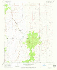
1961 Map of Tres Orejas
USGS Topo · Published 1972About this map
Tres Orejas rises as the central topographic focal point within this 1960s study of the Taos high desert. The landscape is defined by the high-elevation terrain of the Carson National Forest, where drainage patterns are etched into the earth by the Arroyo Aguaje de la Petaca. This drainage flows southward toward the Carson Reservoir, a critical water management feature in this arid environment. The map captures a moment before significant modern development, focusing on natural landmarks and essential livestock or irrigation infrastructure like Dunlap Tank. The isolation of the peaks against the surrounding basin illustrates the classic New Mexico volcanic field geography, providing an essential record for those studying the land use and hydrology of the region during the mid-century era.
Find a feature on this map
5 named features on this map. Tap any name to fly to it.
Don’t see what you’re looking for? This feature index may not catch every label — zoom into the map to look around manually.
Map Details
Editions of this 1961 Tres Orejas Map
2 editions found
Other maps of this area

1954 · Raton
USGS Topo · 1:250,000

1958 · Raton
USGS Topo · 1:250,000

1960 · Taos Junction
USGS Topo · 1:24,000

1961 · Carson
USGS Topo · 1:24,000

1961 · Tres Orejas
USGS Topo · 1:24,000

1961 · Servilleta Plaza
USGS Topo · 1:24,000

1963 · Arroyo Hondo
USGS Topo · 1:24,000

1963 · Cerro De Los Taoses
USGS Topo · 1:24,000
1963 · Petaca Peak
USGS Topo · 1:24,000

1964 · Los Cordovas
USGS Topo · 1:24,000