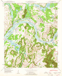
1948 Map of Triana
USGS Topo · Published 1963About this map
The Tennessee River snakes through the heart of this North Alabama landscape, its waters widening into Wheeler Lake just as the post-war industrial and military footprint began to expand. This era captures the transition of the northern bank as the Huntsville Arsenal and Redstone Arsenal occupy vast tracts of land, bordered by the protective reach of the Wheeler National Wildlife Refuge. South of the river, the terrain rises sharply toward Brindley Mountain, where isolated family settlements and rural landmarks like Talucah and Valhermoso Springs are mapped in detail. Genealogists will find a wealth of local landmarks including Draper Cem, Breeding Cem, and Union Sch, alongside prominent high points such as Bradford Mountain and Bald Mountain that overlook the river valley's complex network of creeks and springs.
Find a feature on this map
41 named features on this map. Tap any name to fly to it.
Don’t see what you’re looking for? This feature index may not catch every label — zoom into the map to look around manually.
Map Details
Editions of this 1948 Triana Map
This is the sole edition of this map. No revisions or reprints were ever made.
Other maps of this area

1888 · Cullman
USGS Topo · 1:125,000

1888 · Huntsville
USGS Topo · 1:125,000

1892 · Cullman
USGS Topo · 1:125,000

1892 · Huntsville
USGS Topo · 1:125,000

1936 · Triana
USGS Topo · 1:24,000

1936 · Madison
USGS Topo · 1:24,000

1936 · Somerville
USGS Topo · 1:24,000

1936 · Center Grove
USGS Topo · 1:24,000

1936 · Mason Ridge
USGS Topo · 1:24,000

1936 · Greenbrier
USGS Topo · 1:24,000