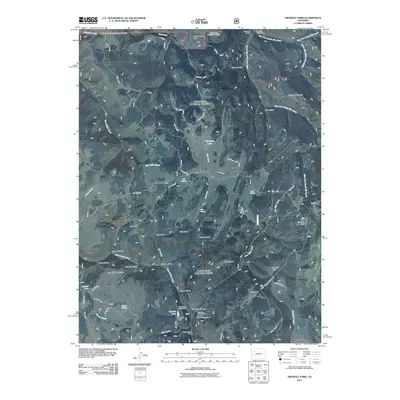
2011 Map of Triangle Park
USGS Topo · Published 2011About this map
Triangle Park sits at the heart of this high-elevation landscape in Garfield County, where the drainages of East Rifle Creek and West Fork North Elk Creek carve through a network of ridges and parks. The land use patterns reflect a long history of seasonal grazing and water management, evidenced by sites like Hamilton Camp and the North Elk Cow Camp in the northern reaches, as well as the Mud Spring Ranch. In the south, the terrain descends toward Coulter Lake, controlled by Coulter Dam, which serves as a recreational anchor alongside the Spruce Picnic Area and several camps including Little Box Canyon Campground. The map reveals a rugged geography defined by family-named landmarks and topographic features like Snowdrift Mountain, Irish Ridge, and the appropriately named Dynamite Lake, all connected by mountain routes like the New Castle Buford Rd.
Find a feature on this map
59 named features on this map. Tap any name to fly to it.
Don’t see what you’re looking for? This feature index may not catch every label — zoom into the map to look around manually.
Map Details
Editions of this 2011 Triangle Park Map
This is the sole edition of this map. No revisions or reprints were ever made.
Other maps of this area

1906 · Grand Hogback
USGS Topo · 1:125,000

1910 · Grand Hogback
USGS Topo · 1:125,000

1952 · Horse Mountain
USGS Topo · 1:24,000

1957 · Leadville
USGS Topo · 1:250,000

1959 · Leadville
USGS Topo · 1:250,000

1960 · Leadville
USGS Topo · 1:250,000

1962 · Leadville
USGS Topo · 1:250,000

1964 · Leadville
USGS Topo · 1:250,000
1966 · Rifle Falls
USGS Topo · 1:24,000
1966 · Meadow Creek Lake
USGS Topo · 1:24,000