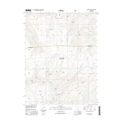
2016 Map of Triangle Park
USGS Topo · Published 2016About this map
White River National Forest lands dominate this high-elevation landscape along the boundary of Garfield and Rio Blanco counties. The terrain is defined by a series of prominent ridges and drainage basins, including the high plateau of Coulter Mesa and the sharp descent into Little Box Canyon. Numerous springs, such as Orphan Spring, Irish Spring, and Mud Spring, feed the complex creek network that includes E Rifle Cr and Fourmile Cr. Historical land use is evidenced by several named clearings or "parks" scattered through the timber, notably Triangle Park, Seaman Park, and Saddle Horse Park. A network of primitive routes like the Wagon Road and New Castle - Buford road provide access to remote landmarks such as Snowdrift Mtn and Dynamite Lake.
Find a feature on this map
66 named features on this map. Tap any name to fly to it.
Don’t see what you’re looking for? This feature index may not catch every label — zoom into the map to look around manually.
Map Details
Editions of this 2016 Triangle Park Map
This is the sole edition of this map. No revisions or reprints were ever made.
Other maps of this area

1906 · Grand Hogback
USGS Topo · 1:125,000

1910 · Grand Hogback
USGS Topo · 1:125,000

1952 · Horse Mountain
USGS Topo · 1:24,000

1957 · Leadville
USGS Topo · 1:250,000

1959 · Leadville
USGS Topo · 1:250,000

1960 · Leadville
USGS Topo · 1:250,000

1962 · Leadville
USGS Topo · 1:250,000

1964 · Leadville
USGS Topo · 1:250,000
1966 · Rifle Falls
USGS Topo · 1:24,000
1966 · Meadow Creek Lake
USGS Topo · 1:24,000