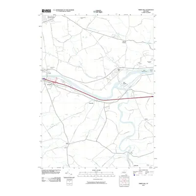
2010 Map of Tribes Hill
USGS Topo · Published 2010About this map
Tribes Hill and Fort Hunter anchor a landscape defined by the convergence of the Mohawk River, Schoharie Creek, and the historic Erie Canal. This corridor, a vital artery of New York transportation, shows the close relationship between water routes and the established settlements of Fonda and Fultonville. The map captures a detailed inventory of regional heritage sites, from the Caughnawaga Cemetery in the west to the Kline Cemetery near the Amsterdam Airfield. To the south, smaller hamlets like Glen and Auriesville are situated along the winding paths of Auries Creek. The transition from the industrial and transport-heavy river valley to the rural reaches of Snooks Corners and Church Corners illustrates the enduring layout of Montgomery and Fulton County farm-to-market roads, such as Albany Bush Rd and Stoners Trl.
Find a feature on this map
76 named features on this map. Tap any name to fly to it.
Don’t see what you’re looking for? This feature index may not catch every label — zoom into the map to look around manually.
Map Details
Editions of this 2010 Tribes Hill Map
This is the sole edition of this map. No revisions or reprints were ever made.
Other maps of this area

1895 · Amsterdam
USGS Topo · 1:62,500

1896 · Fonda
USGS Topo · 1:62,500

1898 · Fonda
USGS Topo · 1:62,500

1899 · Broadalbin
USGS Topo · 1:62,500

1902 · Broadalbin
USGS Topo · 1:62,500

1902 · Fonda
USGS Topo · 1:62,500

1903 · Gloversville
USGS Topo · 1:62,500

1931 · Amsterdam
USGS Topo · 1:62,500

1943 · Gloversville
USGS Topo · 1:62,500
1943 · Carlisle
USGS Topo · 1:24,000