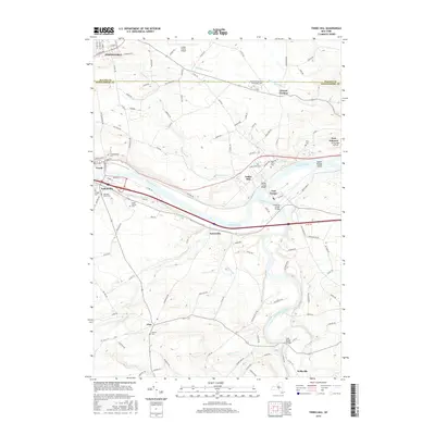
2016 Map of Tribes Hill
USGS Topo · Published 2016About this map
Mohawk River geography and historical transit routes define this region of New York, where the river valley carves a path through the landscape of Fulton Co and Montgomery Co. This corridor includes a concentration of riverside settlements like Fonda, Fultonville, and Tribes Hill, each tied to the waterway's role in trade and travel. The presence of the Barge Canal Bridge and Schoharie Creek Bridge highlights the critical infrastructure required to navigate the confluence of Schoharie Creek and the Mohawk.
Find a feature on this map
119 named features on this map. Tap any name to fly to it.
Don’t see what you’re looking for? This feature index may not catch every label — zoom into the map to look around manually.
Map Details
Editions of this 2016 Tribes Hill Map
This is the sole edition of this map. No revisions or reprints were ever made.
Other maps of this area

1895 · Amsterdam
USGS Topo · 1:62,500

1896 · Fonda
USGS Topo · 1:62,500

1898 · Fonda
USGS Topo · 1:62,500

1899 · Broadalbin
USGS Topo · 1:62,500

1902 · Broadalbin
USGS Topo · 1:62,500

1902 · Fonda
USGS Topo · 1:62,500

1903 · Gloversville
USGS Topo · 1:62,500

1931 · Amsterdam
USGS Topo · 1:62,500

1943 · Gloversville
USGS Topo · 1:62,500
1943 · Carlisle
USGS Topo · 1:24,000