2023 Map of Tribes Hill
USGS Topo · Published 2023About this map
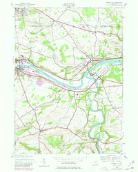
The Mohawk River corridor serves as the central artery for this region of the Mohawk Valley, where the historic settlements of Fonda and Fultonville face each other across the water. This 2023 survey illustrates a landscape deeply tied to colonial history and early New York transit, with the river joined by the Schoharie Creek confluence near Fort Hunter. Cultural and religious landmarks are prominent, including the riverside Auriesville and several legacy burial grounds such as Caughnawaga Cem and Van Epps - Starin Cem. The geography transitions from the river flats into the upland reaches of Church Corners and the border of Johnstown, while institutional hubs like the Fulton-Montgomery Community College and local aviation at Fulton County Airport mark modern development patterns.
Find a feature on this map
121 named features on this map. Tap any name to fly to it.
Don’t see what you’re looking for? This feature index may not catch every label — zoom into the map to look around manually.
Map Details
Editions of this 2023 Tribes Hill Map
This is the sole edition of this map. No revisions or reprints were ever made.
Historical Maps of Fort Hunter Through Time
3 maps found