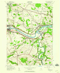
1944 Map of Tribes Hill
USGS Topo · Published 1959About this map
The Mohawk River and the Erie Canal form the industrial and transit spine of this mid-century landscape, flanked by the New York Central Railroad and the newly added New York State Thruway. The map captures a high density of historical religious and cultural landmarks along the river corridor, most notably the Auriesville Shrine and the Reparatrix Convent. North of the river, small crossroads like Albany Bush and Church Corners maintain their agrarian character, connected by a network of rural schools such as School No 2 and the Switzer Hill Sch. To the south, Schoharie Creek meanders toward its confluence, passing Mill Point and Wellsville. This survey documents a critical period of infrastructure growth where traditional canal and rail routes were joined by the high-speed toll roads that would reshape the Mohawk Valley.
Find a feature on this map
49 named features on this map. Tap any name to fly to it.
Don’t see what you’re looking for? This feature index may not catch every label — zoom into the map to look around manually.
Map Details
Editions of this 1944 Tribes Hill Map
2 editions found
Other maps of this area

1895 · Amsterdam
USGS Topo · 1:62,500

1896 · Fonda
USGS Topo · 1:62,500

1898 · Fonda
USGS Topo · 1:62,500

1899 · Broadalbin
USGS Topo · 1:62,500

1902 · Broadalbin
USGS Topo · 1:62,500

1902 · Fonda
USGS Topo · 1:62,500

1903 · Gloversville
USGS Topo · 1:62,500

1931 · Amsterdam
USGS Topo · 1:62,500

1943 · Gloversville
USGS Topo · 1:62,500
1943 · Carlisle
USGS Topo · 1:24,000