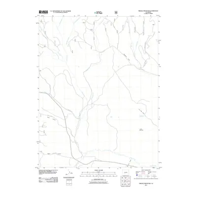
2011 Map of Trickle Mountain
USGS Topo · Published 2011About this map
Trickle Mountain anchors a landscape defined by a complex network of seasonal and perennial drainage systems in Saguache County. The terrain is marked by significant topographical shifts, from the depths of Taylor Canyon and Rabbit Canyon to the high reaches of the mountain. A series of water sources including Alkali Spring and the Lone Pine Reservoir suggest the vital role of water management in this arid region.
Find a feature on this map
26 named features on this map. Tap any name to fly to it.
Don’t see what you’re looking for? This feature index may not catch every label — zoom into the map to look around manually.
Map Details
Editions of this 2011 Trickle Mountain Map
This is the sole edition of this map. No revisions or reprints were ever made.
Other maps of this area

1956 · Montrose
USGS Topo · 1:250,000

1959 · Montrose
USGS Topo · 1:250,000

1960 · Montrose
USGS Topo · 1:250,000

1962 · West Baldy
USGS Topo · 1:24,000
1967 · North Pass
USGS Topo · 1:24,000

1967 · Sargents Mesa
USGS Topo · 1:24,000
1967 · Laughlin Gulch
USGS Topo · 1:24,000

1967 · Trickle Mountain
USGS Topo · 1:24,000
1967 · Grouse Creek
USGS Topo · 1:24,000

1967 · Lake Mountain NE
USGS Topo · 1:24,000