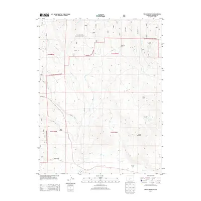
2013 Map of Trickle Mountain
USGS Topo · Published 2013About this map
Trickle Mountain rises as the central landmark in this high-altitude landscape within Saguache County, where the northern reaches of the Rio Grande National Forest meet an intricate network of drainage systems. The terrain is defined by a series of deep cuts including Taylor Canyon, Rabbit Canyon, and Houghland Gulch, all shaped by seasonal water flow. Human presence is largely marked by the path of State Hwy 114 and a web of county roads such as Co Road 31CC, which navigate the difficult topography. Water resources, critical for high-country livestock and wildlife, are concentrated at points like Alkali Spring and the Lone Pine Reservoir. The southern portion of the map is dominated by the wandering course of Saguache Cr, while numerous tributaries like Sheep Cr and Jacks Cr cut through the timbered slopes to the north.
Find a feature on this map
34 named features on this map. Tap any name to fly to it.
Don’t see what you’re looking for? This feature index may not catch every label — zoom into the map to look around manually.
Map Details
Editions of this 2013 Trickle Mountain Map
This is the sole edition of this map. No revisions or reprints were ever made.
Other maps of this area

1956 · Montrose
USGS Topo · 1:250,000

1959 · Montrose
USGS Topo · 1:250,000

1960 · Montrose
USGS Topo · 1:250,000

1962 · West Baldy
USGS Topo · 1:24,000
1967 · North Pass
USGS Topo · 1:24,000

1967 · Sargents Mesa
USGS Topo · 1:24,000
1967 · Laughlin Gulch
USGS Topo · 1:24,000

1967 · Trickle Mountain
USGS Topo · 1:24,000
1967 · Grouse Creek
USGS Topo · 1:24,000

1967 · Lake Mountain NE
USGS Topo · 1:24,000