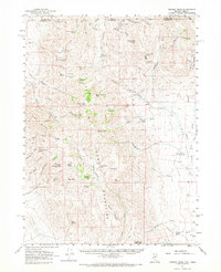
1961 Map of Trident Peak
USGS Topo · Published 1968About this map
Trident Peak and the Black Mountains dominate this high-desert landscape along the border of Nevada and Oregon. The area is defined by a ranching and mining economy, where water sources like Lovely Valley Spring and Baxter Springs were critical for survival. Numerous remnant structures indicate a history of isolated homesteading and prospecting, including the Ayers Cabin (Ruins) and Jack Spade Cabin (Ruins), alongside more established sites like the Kings River Ranch. Small-scale mining operations are scattered through the peaks, evidenced by the Lucky Strike Mine and Hansen Mine. A network of jeep trails connects these remote outposts across the Kings River Valley, tracing a path between landmarks like House Creek Butte and Shyster Butte.
Find a feature on this map
65 named features on this map. Tap any name to fly to it.
Don’t see what you’re looking for? This feature index may not catch every label — zoom into the map to look around manually.
Map Details
Editions of this 1961 Trident Peak Map
2 editions found
Other maps of this area

1886 · Disaster
USGS Topo · 1:250,000

1893 · Disaster
USGS Topo · 1:250,000

1954 · Vya
USGS Topo · 1:250,000

1955 · Adel
USGS Topo · 1:250,000

1957 · Adel
USGS Topo · 1:250,000

1958 · Vya
USGS Topo · 1:250,000

1958 · Adel
USGS Topo · 1:250,000

1961 · Quinn River Crossing
USGS Topo · 1:62,500

1961 · Thacker Pass
USGS Topo · 1:62,500

1961 · Trident Peak
USGS Topo · 1:62,500