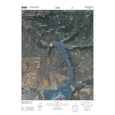
2013 Map of Trimble Point
USGS Topo · Published 2013About this map
The Dolores River valley dominates this portion of Montezuma County, defined by the expansive waters of the McPhee Reservoir. This 2013 survey illustrates a landscape transitioned from river canyon to a major water management and recreation hub within the San Juan National Forest. While the reservoir itself is the most prominent feature, the map meticulously records the complex irrigation infrastructure vital to the region, including the Dove Creek Canal, Lone Pine Lateral, and Moonlight Lateral.
Find a feature on this map
49 named features on this map. Tap any name to fly to it.
Don’t see what you’re looking for? This feature index may not catch every label — zoom into the map to look around manually.
Map Details
Editions of this 2013 Trimble Point Map
This is the sole edition of this map. No revisions or reprints were ever made.
Other maps of this area

1956 · Cortez
USGS Topo · 1:250,000

1958 · Cortez
USGS Topo · 1:250,000

1959 · Cortez
USGS Topo · 1:250,000

1962 · Cortez
USGS Topo · 1:250,000

1965 · Willow Spring
USGS Topo · 1:24,000

1965 · Dolores East
USGS Topo · 1:24,000

1965 · Dolores West
USGS Topo · 1:24,000

1965 · Yellow Jacket
USGS Topo · 1:24,000
1965 · Arriola
USGS Topo · 1:24,000
1965 · Boggy Draw
USGS Topo · 1:24,000