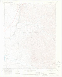
1967 Map of Trinchera Ranch
USGS Topo · Published 1971About this map
The Sangre de Cristo Grant forms the backdrop of this landscape, where high-country drainage systems converge in Costilla County. By the late 1960s, the terrain shows a mix of historical remnants and active ranching operations, centered on the Trinchera Ranch and the small settlement at Mortimer. The Denver and Rio Grande Western railroad tracks run parallel to the Sangre de Cristo Creek, marking a primary transportation corridor through the valley floor.
Find a feature on this map
25 named features on this map. Tap any name to fly to it.
Don’t see what you’re looking for? This feature index may not catch every label — zoom into the map to look around manually.
Map Details
Editions of this 1967 Trinchera Ranch Map
3 editions found
Other maps of this area

1889 · Huerfano Park
USGS Topo · 1:125,000

1892 · Huerfano Park
USGS Topo · 1:125,000

1954 · Trinidad
USGS Topo · 1:250,000

1955 · Trinidad
USGS Topo · 1:250,000

1958 · Trinidad
USGS Topo · 1:250,000

1959 · Trinidad
USGS Topo · 1:250,000

1963 · Mc Carty Park
USGS Topo · 1:24,000

1963 · La Veta Pass
USGS Topo · 1:24,000

1967 · Fort Garland SW
USGS Topo · 1:24,000

1967 · Ojito Peak
USGS Topo · 1:24,000