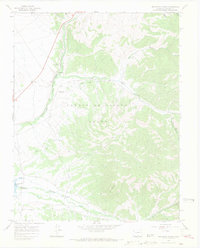
1967 Map of Trinchera Ranch
USGS Topo · Published 1971About this map
The Sangre De Cristo Grant serves as the primary setting for this 1960s study of the southern Colorado foothills. The landscape is dominated by the steep drainages of Trinchera Creek and West Indian Creek, which flow westward toward the Mountain Home Reservoir. Near the northern border, the Denver and Rio Grande railway follows the curves of the terrain, passing through the settlement of Mortimer.
Find a feature on this map
24 named features on this map. Tap any name to fly to it.
Don’t see what you’re looking for? This feature index may not catch every label — zoom into the map to look around manually.
Map Details
Editions of this 1967 Trinchera Ranch Map
3 editions found
Other maps of this area

1889 · Huerfano Park
USGS Topo · 1:125,000

1892 · Huerfano Park
USGS Topo · 1:125,000

1954 · Trinidad
USGS Topo · 1:250,000

1955 · Trinidad
USGS Topo · 1:250,000

1958 · Trinidad
USGS Topo · 1:250,000

1959 · Trinidad
USGS Topo · 1:250,000

1963 · Mc Carty Park
USGS Topo · 1:24,000

1963 · La Veta Pass
USGS Topo · 1:24,000

1967 · Fort Garland SW
USGS Topo · 1:24,000

1967 · Ojito Peak
USGS Topo · 1:24,000