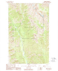
1988 Map of Trinity
USGS Topo · Published 1988About this map
Trinity sits as a central point of human activity within this late-twentieth-century landscape, positioned near the confluence of Phelps Creek and the Chiwawa River. The map highlights a region transitioning from its mining history to a focus on recreation and wilderness preservation. Evidence of industrial roots is found at the Red Mountain Mine, located north of the settlement. Much of the surrounding area is defined by the high-elevation peaks of the Wenatchee National Forest, including Carne Mtn and Old Gib Mtn. The survey documents a network of managed outdoor spaces, including the Phelps Creek Campground, Alpine Meadows Campground, and Atkinson Flat Campground. These sites, along with the Glacier Peak Wilderness boundary, illustrate the late 1980s management of this mountain environment, where drainage systems like the Entiat River and Little Giant Creek carve through the steep terrain of Phelps Ridge.
Find a feature on this map
28 named features on this map. Tap any name to fly to it.
Don’t see what you’re looking for? This feature index may not catch every label — zoom into the map to look around manually.
Map Details
Editions of this 1988 Trinity Map
2 editions found
Other maps of this area

1901 · Chiwaukum
USGS Topo · 1:125,000

1902 · Stehekin
USGS Topo · 1:125,000

1904 · Stehekin
USGS Topo · 1:125,000

1904 · Chiwaukum
USGS Topo · 1:125,000

1944 · Holden
USGS Topo · 1:62,500

1944 · Lucerne
USGS Topo · 1:62,500

1949 · Lucerne
USGS Topo · 1:62,500

1949 · Holden
USGS Topo · 1:62,500

1955 · Concrete
USGS Topo · 1:250,000

1957 · Wenatchee
USGS Topo · 1:250,000