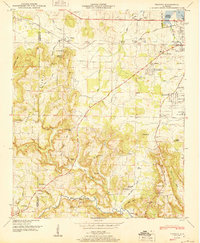
1950 Map of Trinity
USGS Topo · Published 1950About this map
Trinity and the outskirts of Austinville anchor this 1950 portrait of the Tennessee River valley, where the newly managed waters of the Wheeler Reservoir meet the rising slopes of Trinity Mountain. The landscape is a mix of agricultural bottomlands and elevated ridges dotted with family cemeteries such as Lile Cem and Fennell Cem. The Southern railroad line parallels the Joe Wheeler Highway, facilitating the movement of goods between rural outposts like Wolftown and the growing residential developments of Moulton Heights and Griffin Addition.
Find a feature on this map
65 named features on this map. Tap any name to fly to it.
Don’t see what you’re looking for? This feature index may not catch every label — zoom into the map to look around manually.
Map Details
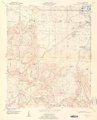
Editions of this 1950 Trinity Map
2 editions found
Other maps of this area

1888 · Cullman
USGS Topo · 1:125,000

1888 · Huntsville
USGS Topo · 1:125,000

1892 · Cullman
USGS Topo · 1:125,000

1892 · Huntsville
USGS Topo · 1:125,000

1935 · Danville
USGS Topo · 1:48,000

1935 · Oakville
USGS Topo · 1:24,000

1936 · Caddo
USGS Topo · 1:24,000

1936 · Hartselle
USGS Topo · 1:24,000

1936 · Decatur
USGS Topo · 1:24,000

1936 · Stewart Cross Roads
USGS Topo · 1:24,000