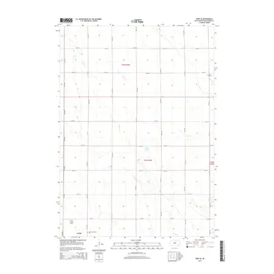
2015 Map of Tripp SE
USGS Topo · Published 2015About this map
Bohemian National Cem and Freidenthal Cem are prominent cultural landmarks on this landscape, reflecting the heritage and settlement patterns of this corner of South Dakota. The topography is defined by the subtle drainage systems of Snatch Cr, Beaver Cr, and Prairie Cr, which carve through the agricultural grid. To the southwest, the town of Tyndall serves as a local hub, adjacent to the Plihal Farms Airport. The presence of Clear Lake provides a localized water feature amidst the expansive township and range sections. The map reveals the rigid organization of rural life, with a dense network of numbered roads like 416th Ave and 300th St connecting isolated farmsteads and agricultural plots across t96n r59w and t95n r59w.
Find a feature on this map
25 named features on this map. Tap any name to fly to it.
Don’t see what you’re looking for? This feature index may not catch every label — zoom into the map to look around manually.
Map Details
Editions of this 2015 Tripp SE Map
This is the sole edition of this map. No revisions or reprints were ever made.
Other maps of this area

1898 · Olivet
USGS Topo · 1:125,000

1955 · Sioux City
USGS Topo · 1:250,000

1955 · Sioux Falls
USGS Topo · 1:250,000

1957 · Scotland
USGS Topo · 1:24,000

1958 · Sioux City
USGS Topo · 1:250,000

1958 · Sioux Falls
USGS Topo · 1:250,000

1959 · Sioux City
USGS Topo · 1:250,000

1978 · Tripp SE
USGS Topo · 1:24,000
1978 · Kloucek Lake
USGS Topo · 1:24,000
1978 · Tyndall
USGS Topo · 1:24,000
Featured Places
- Washington Township, SD
- Emanuel Township, SD
- Scotland Township, SD
- Franklin Township, SD
- Jackson Township, SD