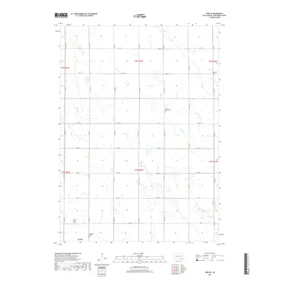
2017 Map of Tripp SE
USGS Topo · Published 2017About this map
Tyndall anchors the southwestern corner of this survey, where the prairie landscape is defined by the rigid grid of the Public Land Survey System. The area is divided by numerous sections of t95n r59w and neighboring townships, reflecting the late 20th and early 21st-century agricultural continuity of Bon Homme County. Waterways like Beaver Creek and Snatch Creek meander across the rectilinear road network, which includes 416th Ave and 300th St. Local history is preserved in several burial grounds, including the Freidensthal Cem and the Bohemian National Cem, the latter noting the area's specific ethnic settlement patterns. Small aviation is represented by the Plihal Farms Airport, while Clear Lake serves as a notable natural hydrologic feature amidst the expansive farmstead plots.
Find a feature on this map
29 named features on this map. Tap any name to fly to it.
Don’t see what you’re looking for? This feature index may not catch every label — zoom into the map to look around manually.
Map Details
Editions of this 2017 Tripp SE Map
This is the sole edition of this map. No revisions or reprints were ever made.
Other maps of this area

1898 · Olivet
USGS Topo · 1:125,000

1955 · Sioux City
USGS Topo · 1:250,000

1955 · Sioux Falls
USGS Topo · 1:250,000

1957 · Scotland
USGS Topo · 1:24,000

1958 · Sioux City
USGS Topo · 1:250,000

1958 · Sioux Falls
USGS Topo · 1:250,000

1959 · Sioux City
USGS Topo · 1:250,000

1978 · Tripp SE
USGS Topo · 1:24,000
1978 · Kloucek Lake
USGS Topo · 1:24,000
1978 · Tyndall
USGS Topo · 1:24,000
Featured Places
- Washington Township, SD
- Emanuel Township, SD
- Scotland Township, SD
- Franklin Township, SD
- Jackson Township, SD