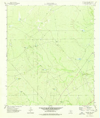
1974 Map of Trosado Tank
USGS Topo · Published 1977About this map
Salado Creek and Mustang Creek wind through this arid Maverick County landscape, defined by a sophisticated network of water management features essential for Texas ranching. The map captures an era of livestock production where named tanks like Welta Tank, Gilbo Tank, and Trosado Tank served as critical hubs for cattle. The presence of the Gallina Windmill and various catchments such as Marranos Tank and Pescado Tank illustrate the reliance on groundwater and seasonal runoff in this brush country terrain. Beyond ranching, the region's industrial infrastructure is visible through a prominent pipeline corridor and a small Gravel Pit, showing the intersection of traditional land use with 20th-century resource extraction. This survey provides a clear view of the drainage patterns for Chilipitin Creek and Elm Creek before modern developments altered the local watersheds.
Find a feature on this map
17 named features on this map. Tap any name to fly to it.
Don’t see what you’re looking for? This feature index may not catch every label — zoom into the map to look around manually.
Map Details
Editions of this 1974 Trosado Tank Map
This is the sole edition of this map. No revisions or reprints were ever made.
Other maps of this area

1896 · Brackett
USGS Topo · 1:125,000

1897 · Brackett
USGS Topo · 1:125,000

1940 · Paloma
USGS Topo · 1:62,500

1940 · Chacon Creek
USGS Topo · 1:62,500

1944 · Spofford
USGS Topo · 1:62,500

1949 · Cline
USGS Topo · 1:62,500

1958 · Eagle Pass
USGS Topo · 1:250,000

1958 · Del Rio
USGS Topo · 1:250,000

1964 · Del Rio
USGS Topo · 1:250,000

1965 · Eagle Pass
USGS Topo · 1:250,000