
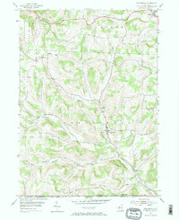
1954 Map of Troupsburg
USGS Topo · Published 1956About this map
The hills of Steuben County in the mid-1950s are defined by a network of hollows and small farming communities clustered along the winding path of Troups Creek. The township of Troupsburg serves as a central hub, while smaller hamlets like Young Hickory, Alice, and Lila occupy the narrow valleys created by drainages such as Hickory Hollow and Squab Hollow. The landscape is heavily agricultural and rural, with numerous family and community burial grounds, including Mt Vernon Cem and Mt Hope Cem, scattered near the road intersections.
Find a feature on this map
26 named features on this map. Tap any name to fly to it.
Don’t see what you’re looking for? This feature index may not catch every label — zoom into the map to look around manually.
Map Details
Editions of this 1954 Troupsburg Map
2 editions found
Other maps of this area

1899 · Gaines
USGS Topo · 1:62,500

1900 · Gaines
USGS Topo · 1:62,500

1900 · Elkland
USGS Topo · 1:62,500

1924 · Woodhull
USGS Topo · 1:48,000

1926 · Woodhull
USGS Topo · 1:62,500

1926 · Greenwood
USGS Topo · 1:62,500

1944 · Woodhull
USGS Topo · 1:62,500

1950 · Elmira
USGS Topo · 1:250,000

1953 · Cameron
USGS Topo · 1:24,000

1953 · Woodhull
USGS Topo · 1:24,000