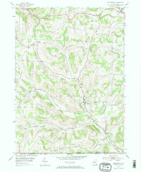
1954 Map of Troupsburg
USGS Topo · Published 1972About this map
Troupsburg and the surrounding rural uplands of Steuben County are defined by a network of narrow hollows and high ridges along the New York and Pennsylvania border. In the mid-1950s, the landscape remained predominantly agricultural, with small hamlets like Young Hickory and Highup situated at key intersections and drainage points. The mapping shows a significant number of family-associated burial grounds and community markers, including Mt Hope Cem, Rogers Cem, and Mt Vernon Cem, which serve as vital reference points for genealogical research in this border region. The course of Troups Creek dictates the primary travel corridors through the southern portion of the quadrangle, passing through South Troupsburg as it flows toward the Tioga County line. Local transit was centered on routes like Potter Street and the northern Highway near Jasper, reflecting a traditional rural infrastructure before major modern developments altered the local character.
Find a feature on this map
30 named features on this map. Tap any name to fly to it.
Don’t see what you’re looking for? This feature index may not catch every label — zoom into the map to look around manually.
Map Details
Editions of this 1954 Troupsburg Map
2 editions found

Other maps of this area

1899 · Gaines
USGS Topo · 1:62,500

1900 · Gaines
USGS Topo · 1:62,500

1900 · Elkland
USGS Topo · 1:62,500

1924 · Woodhull
USGS Topo · 1:48,000

1926 · Woodhull
USGS Topo · 1:62,500

1926 · Greenwood
USGS Topo · 1:62,500

1944 · Woodhull
USGS Topo · 1:62,500

1950 · Elmira
USGS Topo · 1:250,000

1953 · Cameron
USGS Topo · 1:24,000

1953 · Woodhull
USGS Topo · 1:24,000