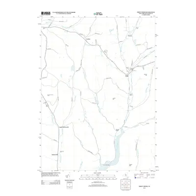
2013 Map of Trout Creek
USGS Topo · Published 2013About this map
Trout Creek and its neighboring hamlets sit within a landscape of carved valleys and high ridges in Delaware County. This 2013 survey illustrates the modern layout of rural settlements like Ivanhoe, Tacoma, and Barbourville, situated along historical watercourses such as Sherruck Brook and W Br Trout Cr. The southern portion of the map is dominated by the northern reaches of the Cannonsville Reservoir, where the waters of Johnny Brook and Dry Brook meet the main impoundment. For genealogists and local historians, the sheet is particularly valuable for its documentation of family and community burial grounds, including the Pioneer Cem near the northern boundary and Austin Cem in the heart of Trout Creek. From the peak of Clabber Peak to the wooded slopes of Herrick Hollow, the map provides a contemporary record of land use, including the Hardwood Hills Golf Course and the Brace Youth Camp near the western edge.
Find a feature on this map
69 named features on this map. Tap any name to fly to it.
Don’t see what you’re looking for? This feature index may not catch every label — zoom into the map to look around manually.
Map Details
Editions of this 2013 Trout Creek Map
This is the sole edition of this map. No revisions or reprints were ever made.
Other maps of this area

1915 · Oneonta
USGS Topo · 1:62,500

1915 · Unadilla
USGS Topo · 1:62,500

1918 · Unadilla
USGS Topo · 1:62,500

1918 · Oneonta
USGS Topo · 1:62,500

1923 · Walton
USGS Topo · 1:48,000

1924 · Deposit
USGS Topo · 1:62,500

1925 · Walton
USGS Topo · 1:62,500

1926 · Deposit
USGS Topo · 1:62,500

1943 · Sidney
USGS Topo · 1:24,000

1943 · Franklin
USGS Topo · 1:24,000