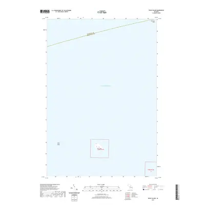
2019 Map of Trout Island
USGS Topo · Published 2019About this map
Trout Island sits as a solitary landmass in the northern reaches of Lake Michigan, positioned within the jurisdictional waters of Saint James Township. This 2019 survey delineates the small island's topographic contours and its relationship to the surrounding aquatic features, including the Trout Island Shoal to its west and the Muskegon Basin to the northeast. A significant maritime boundary is noted across the northern portion of the sheet, marking the dividing line between Mackinac and Charlevoix Counties. The map provides a precise look at the Public Land Survey System grid, specifically identifying Section 17 of Township 39 North, Range 11 West, which encompasses the island. This record is essential for understanding the remote geography of the Beaver Island archipelago during the early twenty-first century.
Find a feature on this map
7 named features on this map. Tap any name to fly to it.
Don’t see what you’re looking for? This feature index may not catch every label — zoom into the map to look around manually.
Map Details
Editions of this 2019 Trout Island Map
This is the sole edition of this map. No revisions or reprints were ever made.
Other maps of this area

1931 · Seul Choix Point NE
USGS Topo · 1:31,680

1955 · Gull Island
USGS Topo · 1:62,500

1955 · Cheboygan
USGS Topo · 1:250,000

1956 · Beaver Island
USGS Topo · 1:62,500

1958 · Cheboygan
USGS Topo · 1:250,000

1972 · Hughes Point
USGS Topo · 1:24,000
1973 · Point Patterson
USGS Topo · 1:24,000
1980 · Garden Island West
USGS Topo · 1:24,000

1984 · Beaver Island
USGS Topo · 1:100,000

1986 · High Island
USGS Topo · 1:24,000