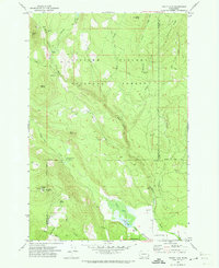
1970 Map of Trout Lake
USGS Topo · Published 1973About this map
Gifford Pinchot National Forest dominates this 1970 landscape, where the White Salmon River and its numerous tributaries like Trout Lake Creek and Gotchen Creek carve through the terrain. The community of Trout Lake serves as a central point, supported by early aviation infrastructure at the Landing Strip and forest management facilities. High points such as Flattop Mtn, featuring a Lookout and Radio Tower, and Haystack Butte provide survey vantage points over the dense timber. Local landmarks like the Trout Lake Big Tree and the Wicky Creek Shelter highlight the area's history as a destination for outdoor recreation and forestry. The map also captures the essential water management of the era, including a prominent Aqueduct and multiple Gaging Stations along the river systems.
Find a feature on this map
42 named features on this map. Tap any name to fly to it.
Don’t see what you’re looking for? This feature index may not catch every label — zoom into the map to look around manually.
Map Details
Editions of this 1970 Trout Lake Map
This is the sole edition of this map. No revisions or reprints were ever made.
Other maps of this area

1904 · Mount Adams
USGS Topo · 1:125,000

1907 · Mount Adams
USGS Topo · 1:125,000

1926 · Steamboat Mtn
USGS Topo · 1:125,000

1926 · Hood River
USGS Topo · 1:125,000

1929 · Hood River
USGS Topo · 1:125,000

1931 · Steamboat Mtn
USGS Topo · 1:125,000

1934 · The Dalles
USGS Topo · 1:125,000

1950 · Yakima
USGS Topo · 1:250,000

1953 · The Dalles
USGS Topo · 1:250,000

1956 · The Dalles
USGS Topo · 1:250,000