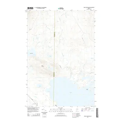
2014 Map of Trout Mountain
USGS Topo · Published 2014About this map
Trout Mountain dominates the western interior of this wilderness area at the boundary of Piscataquis and Penobscot counties. The landscape is defined by an extensive network of waterways and ponds, including the large expanse of Millinocket Lake to the south and the Mud Brook Flowage to the east. Navigational landmarks like State Island and Powers Point punctuate the lakefront, while smaller bodies of water like Tea Pond and Twin Ponds are tucked into the higher elevations. This region is accessed via a series of utilitarian routes, including the Baxter Park Rd and the Golden Rd, alongside numerous forest paths like the Park Tote Rd and Logging Rd. The drainage pattern is complex, with Sandy Stream and Big Mud Brook carving through the terrain to feed the larger lake system.
Find a feature on this map
28 named features on this map. Tap any name to fly to it.
Don’t see what you’re looking for? This feature index may not catch every label — zoom into the map to look around manually.
Map Details
Editions of this 2014 Trout Mountain Map
This is the sole edition of this map. No revisions or reprints were ever made.
Other maps of this area

1927 · Katahdin
USGS Topo · 1:48,000

1930 · Katahdin
USGS Topo · 1:62,500

1949 · Katahdin
USGS Topo · 1:62,500

1951 · Norcross
USGS Topo · 1:62,500

1951 · Millinocket
USGS Topo · 1:62,500

1953 · Stacyville
USGS Topo · 1:62,500

1954 · Millinocket
USGS Topo · 1:250,000

1958 · Millinocket
USGS Topo · 1:250,000

1960 · Millinocket
USGS Topo · 1:250,000
1975 · Stacyville NW
USGS Topo · 1:24,000