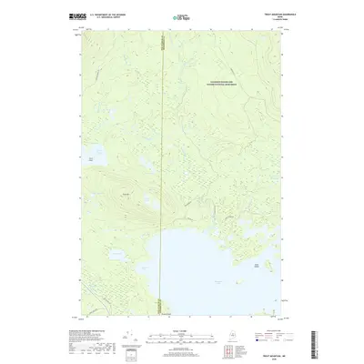
2018 Map of Trout Mountain
USGS Topo · Published 2018About this map
Katahdin Woods and Waters National Monument dominates the northern reaches of this Maine landscape, where the administrative boundary between Piscataquis and Penobscot counties runs through a dense network of waterways. The terrain is defined by its complex hydrography, featuring significant bodies such as Millinocket Lake at the southern edge and Lower Togue Pond further west. High ground is marked by Trout Mtn and Oak Hill Pond, while the lowlands are saturated with marshes and flowages including Mud Brook Flowage.
Find a feature on this map
30 named features on this map. Tap any name to fly to it.
Don’t see what you’re looking for? This feature index may not catch every label — zoom into the map to look around manually.
Map Details
Editions of this 2018 Trout Mountain Map
This is the sole edition of this map. No revisions or reprints were ever made.
Other maps of this area

1927 · Katahdin
USGS Topo · 1:48,000

1930 · Katahdin
USGS Topo · 1:62,500

1949 · Katahdin
USGS Topo · 1:62,500

1951 · Norcross
USGS Topo · 1:62,500

1951 · Millinocket
USGS Topo · 1:62,500

1953 · Stacyville
USGS Topo · 1:62,500

1954 · Millinocket
USGS Topo · 1:250,000

1958 · Millinocket
USGS Topo · 1:250,000

1960 · Millinocket
USGS Topo · 1:250,000
1975 · Stacyville NW
USGS Topo · 1:24,000