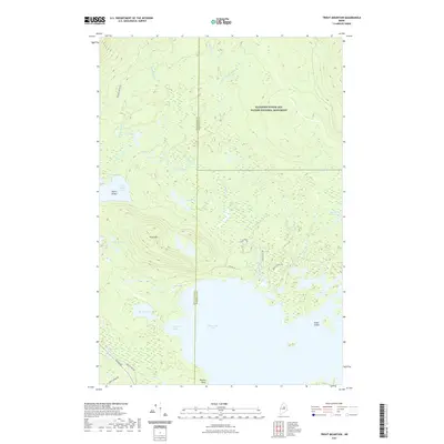
2021 Map of Trout Mountain
USGS Topo · Published 2021About this map
The Katahdin Woods and Waters National Monument dominates this portion of the Maine north woods, showing a landscape defined by its glacial waterways and timber-harvesting history. The northern shoreline of Millinocket Lake provides a natural anchor for the area, featuring Pickerel Cove and the prominent Powers Point. The terrain rises toward Trout Mtn and Oak Hill Pond, while a network of woods roads like Tote Rd 16 and the famous Golden Rd trace the paths of industrial logging access. Along the border between Piscataquis and Penobscot Counties, the map documents a transition from deep water bodies like Lower Togue Pond to smaller mountain basins including Tea Pond. This recent survey captures the modern conservation status of the region, where recreational routes such as the Logan Pond Trl now coexist with established thoroughfares like Baxter Park Rd.
Find a feature on this map
31 named features on this map. Tap any name to fly to it.
Don’t see what you’re looking for? This feature index may not catch every label — zoom into the map to look around manually.
Map Details
Editions of this 2021 Trout Mountain Map
This is the sole edition of this map. No revisions or reprints were ever made.
Other maps of this area

1927 · Katahdin
USGS Topo · 1:48,000

1930 · Katahdin
USGS Topo · 1:62,500

1949 · Katahdin
USGS Topo · 1:62,500

1951 · Norcross
USGS Topo · 1:62,500

1951 · Millinocket
USGS Topo · 1:62,500

1953 · Stacyville
USGS Topo · 1:62,500

1954 · Millinocket
USGS Topo · 1:250,000

1958 · Millinocket
USGS Topo · 1:250,000

1960 · Millinocket
USGS Topo · 1:250,000
1975 · Stacyville NW
USGS Topo · 1:24,000