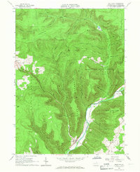
1965 Map of Trout Run
USGS Topo · Published 1967About this map
Lycoming Creek carves a deep path through this corner of the Pennsylvania Alleghenies, framing the settlement of Trout Run and the riverside operations at Fields Station. In the mid-1960s, the Pennsylvania Railroad still traces the water’s edge, serving as a primary transit corridor alongside Pennsylvania 14. The landscape is defined by its massive ridges and state-managed timberlands, including the eastern reaches of the Tiadaghton State Forest and State Game Lands No 133.
Find a feature on this map
68 named features on this map. Tap any name to fly to it.
Don’t see what you’re looking for? This feature index may not catch every label — zoom into the map to look around manually.
Map Details
Editions of this 1965 Trout Run Map
Other maps of this area

1921 · Trout Run
USGS Topo · 1:62,500

1923 · Trout Run
USGS Topo · 1:62,500

1925 · Blossburg
USGS Topo · 1:62,500

1927 · Blossburg
USGS Topo · 1:62,500

1930 · Warrensville
USGS Topo · 1:62,500

1934 · Warrensville
USGS Topo · 1:62,500

1942 · Canton
USGS Topo · 1:62,500

1944 · Blossburg
USGS Topo · 1:62,500

1944 · Trout Run
USGS Topo · 1:62,500

1944 · Canton
USGS Topo · 1:62,500
Featured Places
- Cogan House Township, PA
- Caldwell, Lewis Township
- Trout Run, Lewis Township
- Jackson Township, PA
- Lewis Township, PA