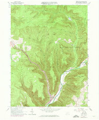
1965 Map of Trout Run
USGS Topo · Published 1973About this map
Trout Run serves as a central hub in this Lycoming County landscape, where the Penn Central railroad tracks follow the winding course of Lycoming Creek. The settlement pattern reflects the constraints of the high plateaus, with most activity concentrated in the narrow valleys or along the lower slopes of massive landforms like McIntyre Mountain and Laurel Mountain. In the south, the community around Gamble preserves local history through the Rose Valley School and Rose Valley Cemetery.
Find a feature on this map
72 named features on this map. Tap any name to fly to it.
Don’t see what you’re looking for? This feature index may not catch every label — zoom into the map to look around manually.
Map Details
Editions of this 1965 Trout Run Map
Other maps of this area

1921 · Trout Run
USGS Topo · 1:62,500

1923 · Trout Run
USGS Topo · 1:62,500

1925 · Blossburg
USGS Topo · 1:62,500

1927 · Blossburg
USGS Topo · 1:62,500

1930 · Warrensville
USGS Topo · 1:62,500

1934 · Warrensville
USGS Topo · 1:62,500

1942 · Canton
USGS Topo · 1:62,500

1944 · Blossburg
USGS Topo · 1:62,500

1944 · Trout Run
USGS Topo · 1:62,500

1944 · Canton
USGS Topo · 1:62,500
Featured Places
- Cogan House Township, PA
- Caldwell, Lewis Township
- Trout Run, Lewis Township
- Jackson Township, PA
- Lewis Township, PA